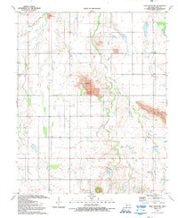
1991 Map of Unap Mountain
USGS Topo · Published 1992About this map
Unap Mountain and its massive central Quarry dominate this landscape of the Oklahoma plains in the early 1990s. The region is defined by distinct topographical rises and a network of drainages including Sugar Creek and Longhorn Creek. Near the community of Sedan, the terrain transitions from flat agricultural parcels into the more prominent elevations of Rainy Mountain and Longhorn Mountain. Local life and aviation history are evident at the Sugar Creek Ranch Landing Field in the southeast, while the Union Dale Church and Union Dale Cem serve as focal points for the rural community. Industrial activity is visible through a Gravel Pit and large-scale excavations on the slopes of the mountains, illustrating how the natural landforms have been utilized for resources while the surrounding plains remained dedicated to ranching and farming.
Find a feature on this map
13 named features on this map. Tap any name to fly to it.
Don’t see what you’re looking for? This feature index may not catch every label — zoom into the map to look around manually.
Map Details
Editions of this 1991 Unap Mountain Map
This is the sole edition of this map. No revisions or reprints were ever made.
Other maps of this area

1949 · Cooperton
USGS Topo · 1:62,500

1950 · Saddle Mountain
USGS Topo · 1:62,500

1955 · Lawton
USGS Topo · 1:250,000

1955 · Clinton
USGS Topo · 1:250,000

1956 · Glen Mountains
USGS Topo · 1:24,000

1956 · Saddle Mountain
USGS Topo · 1:24,000

1956 · Cooperton
USGS Topo · 1:24,000

1956 · Bally Mountain
USGS Topo · 1:24,000

1956 · Unap Mountain
USGS Topo · 1:24,000

1956 · Rainy Mountain Creek
USGS Topo · 1:24,000