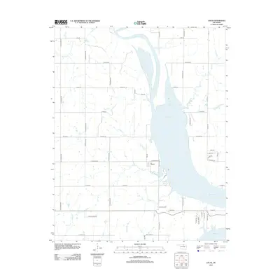
2012 Map of Uncas
USGS Topo · Published 2012About this map
Kaw Lake dominates this Oklahoma landscape, a reservoir that reshaped the geography of Kay County by submerging former river bottomlands. The settlement of Uncas sits on the western shore of the lake, positioned near Coon Creek Cove and Coon Cr. The map reveals a transition from traditional section-line agriculture to lakeside developments, evident in residential clusters like Timberline Hts and Rhgato Acres Rd. A complex network of creeks, including Sweetwater Cr, Possum Cr, and Fishhook Cr, feed into the lake, marking the original drainage patterns of the plains. Shoreline access is maintained through routes such as Lake Rd and Rocky Ridge RD, reflecting the area's modern role as a recreation and residential hub established decades after the damming of the Arkansas River.
Find a feature on this map
54 named features on this map. Tap any name to fly to it.
Don’t see what you’re looking for? This feature index may not catch every label — zoom into the map to look around manually.
Map Details
Editions of this 2012 Uncas Map
This is the sole edition of this map. No revisions or reprints were ever made.
Other maps of this area

1935 · Kaw
USGS Topo · 1:62,500

1936 · Belford
USGS Topo · 1:62,500

1955 · Enid
USGS Topo · 1:250,000

1958 · Enid
USGS Topo · 1:250,000

1963 · Charley Creek
USGS Topo · 1:24,000

1963 · Uncas
USGS Topo · 1:24,000

1963 · Kaw City NW
USGS Topo · 1:24,000

1964 · Charley Creek NE
USGS Topo · 1:24,000

1964 · Kaw City
USGS Topo · 1:24,000
1964 · Hardy
USGS Topo · 1:24,000