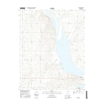
2016 Map of Uncas
USGS Topo · Published 2016About this map
Kaw Lake dominates the central corridor of this Oklahoma landscape, where the waters of the Arkansas River valley meet the rolling terrain of the Kay Co and Osage Co border. The settlement of Uncas sits on the western shore, positioned near the mouth of Coon Cr and its associated Coon Creek Cove. Further south, the community of Kaw City marks the edge of the reservoir near the junction of E Coleman Rd. The map reveals a transition from the structured agricultural grid of roads like Kildare Rd and N Longwood Rd to the more varied topography of the lake's eastern shore, where Timberline Hts rises above the water. This 2016 survey captures the area’s modern geography, including numerous small tributaries such as Possum Cr and Bear Cr that feed into the vast reservoir, while the Oak Grove Cem remains a preserved point of local heritage.
Find a feature on this map
53 named features on this map. Tap any name to fly to it.
Don’t see what you’re looking for? This feature index may not catch every label — zoom into the map to look around manually.
Map Details
Editions of this 2016 Uncas Map
This is the sole edition of this map. No revisions or reprints were ever made.
Other maps of this area

1935 · Kaw
USGS Topo · 1:62,500

1936 · Belford
USGS Topo · 1:62,500

1955 · Enid
USGS Topo · 1:250,000

1958 · Enid
USGS Topo · 1:250,000

1963 · Charley Creek
USGS Topo · 1:24,000

1963 · Uncas
USGS Topo · 1:24,000

1963 · Kaw City NW
USGS Topo · 1:24,000

1964 · Charley Creek NE
USGS Topo · 1:24,000

1964 · Kaw City
USGS Topo · 1:24,000
1964 · Hardy
USGS Topo · 1:24,000