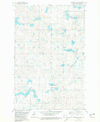
1980 Map of Underdahl Lake
USGS Topo · Published 1981About this map
Glacial prairie potholes and wetland conservation efforts define this Ward County landscape as surveyed in the late 1970s. The region is characterized by township boundaries like Rolling Green, Tolgen, and Anna, which reflect the early land organization of the North Dakota plains. The map is dominated by aquatic features and protected habitats, notably the National Waterfowl Production Area and the namesake Underdahl Lake. Smaller bodies of water such as Melland Lake dot the terrain, interspersed with agricultural land and several Gravel Pits that suggest local road-building or industrial activity. Local genealogy is anchored by the Helland Cem, a small burial site providing a fixed point of historical reference amidst the shifting sloughs and farmsteads of Linto N and Van G.
Find a feature on this map
12 named features on this map. Tap any name to fly to it.
Don’t see what you’re looking for? This feature index may not catch every label — zoom into the map to look around manually.
Map Details
Editions of this 1980 Underdahl Lake Map
This is the sole edition of this map. No revisions or reprints were ever made.
Other maps of this area

1954 · Minot
USGS Topo · 1:250,000

1954 · McClusky
USGS Topo · 1:250,000

1958 · McClusky
USGS Topo · 1:250,000

1958 · Minot
USGS Topo · 1:250,000

1980 · Minot
USGS Topo · 1:100,000

1980 · Lake Vernon
USGS Topo · 1:24,000

1980 · Plaza SE
USGS Topo · 1:24,000

1980 · Makoti
USGS Topo · 1:24,000

1980 · Rice Lake NW
USGS Topo · 1:24,000
1980 · Mork Lake
USGS Topo · 1:24,000