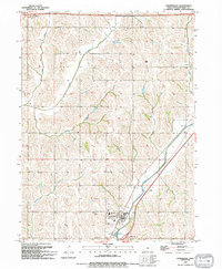
1994 Map of Underwood
USGS Topo · Published 1994About this map
Underwood serves as the primary hub of this Pottawattamie County landscape, situated at the confluence of local infrastructure and undulating terrain. The community is well-documented with its High Sch and Middle Sch located near the town center, providing clear reference points for local historians. The surrounding countryside is defined by an intricate drainage system, with Mosquito Creek and Pigeon Creek carving through the agricultural land, alongside smaller tributaries like Onion Creek and Potato Creek. For those researching family history, the map precisely locates Castor Cem to the north and Fisher Cem to the west of the main settlement. These landmarks, combined with utilities like the Radio Tower and Water Tank, provide a comprehensive view of the area's rural and civic development by the mid-1990s.
Find a feature on this map
16 named features on this map. Tap any name to fly to it.
Don’t see what you’re looking for? This feature index may not catch every label — zoom into the map to look around manually.
Map Details
Editions of this 1994 Underwood Map
This is the sole edition of this map. No revisions or reprints were ever made.
Other maps of this area

1893 · Omaha
USGS Topo · 1:62,500

1954 · Omaha
USGS Topo · 1:250,000

1956 · Underwood
USGS Topo · 1:24,000

1956 · Council Bluffs North
USGS Topo · 1:24,000

1956 · Neola
USGS Topo · 1:24,000

1956 · Mc Clelland
USGS Topo · 1:24,000

1957 · Omaha
USGS Topo · 1:250,000

1957 · Taylor
USGS Topo · 1:24,000

1957 · Honey Creek
USGS Topo · 1:24,000

1958 · Omaha
USGS Topo · 1:250,000