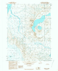
1989 Map of Unimak C-2
USGS Topo · Published 1989About this map
Fisher Caldera dominates the interior of Unimak Island, its massive depression serving as the centerpiece of this volcanic landscape. This 1989 provisional map documents a land shaped by dramatic geological activity, with the towering heights of Westdahl Peak and Eickelberg Peak punctuating the skyline. The coastline is defined by the sheltered waters of Dublin Bay and the narrow inlet at Promontory Cove, providing the only relief from the rugged Aleutian terrain. Much of this territory is preserved within the Aleutian Islands Wilderness and the Alaska Maritime National Wildlife Refuge, reflecting its status as a protected ecological zone. Drainage from the mountain peaks flows through the Pogromni River, illustrating the complex water patterns that define this subarctic environment in the late twentieth century.
Find a feature on this map
9 named features on this map. Tap any name to fly to it.
Don’t see what you’re looking for? This feature index may not catch every label — zoom into the map to look around manually.
Map Details
Editions of this 1989 Unimak C-2 Map
This is the sole edition of this map. No revisions or reprints were ever made.
Other maps of this area

1951 · Unimak
USGS Topo · 1:250,000

1958 · Unimak
USGS Topo · 1:250,000
1958 · Unimak B-2 NE
USGS Topo · 1:25,000

1989 · Unimak C-1
USGS Topo · 1:63,360
1989 · Unimak D-2
USGS Topo · 1:63,360
1989 · Unimak D-1
USGS Topo · 1:63,360
1989 · Unimak B-3
USGS Topo · 1:63,360
1989 · Unimak B-2
USGS Topo · 1:63,360
1989 · Unimak C-3
USGS Topo · 1:63,360
2020 · Unimak B-2 NW
USGS Topo · 1:25,000