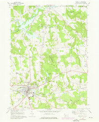
1968 Map of Union City
USGS Topo · Published 1976About this map
Union City stands as the primary hub of this 1968 landscape, situated at the junction of the Penn Central and Erie-Lackawanna railroads. The town’s social and civic infrastructure is well-defined, featuring landmarks such as the Memorial Hospital, High Sch, and the local St Teresa Cem. North of the settlement, the Union City Reservoir on Bentley Run provides a central water source, while the surrounding terrain is marked by significant elevation changes at Hopson Hill and Haskell Hill. The rural township character is maintained through outlying crossroads like Arbuckle and Kimble Corners, alongside smaller community anchors such as the Union-Amity Ch and Hatch Hollow Ch. The map illustrates a region transitioning between concentrated industrial rail activity and the expansive terrain of State Game Lands No 162.
Find a feature on this map
57 named features on this map. Tap any name to fly to it.
Don’t see what you’re looking for? This feature index may not catch every label — zoom into the map to look around manually.
Map Details
Editions of this 1968 Union City Map
Other maps of this area

1905 · Clymer
USGS Topo · 1:62,500

1913 · North East
USGS Topo · 1:62,500

1915 · North East
USGS Topo · 1:62,500

1929 · Corry
USGS Topo · 1:48,000

1929 · Union City
USGS Topo · 1:62,500

1932 · Corry
USGS Topo · 1:62,500

1932 · Union City
USGS Topo · 1:62,500

1939 · Clymer
USGS Topo · 1:62,500

1941 · Clymer
USGS Topo · 1:62,500

1943 · North East
USGS Topo · 1:62,500