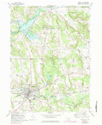
1968 Map of Union City
USGS Topo · Published 1984About this map
Union City serves as a significant rail and water hub in this late-1960s survey, where the Penn Central and Erie-Lackawanna railroads converge near the South Branch French Creek. The landscape is a mix of industrial infrastructure, such as the Filtration Plant and Sewage Disposal, and established civic life centered around the Memorial Hospital and High School. To the north and east, the terrain transitions into protected lands like State Game Lands No 162, while the Union City Reservoir on Bentley Run provides a central water feature for the township.
Find a feature on this map
62 named features on this map. Tap any name to fly to it.
Don’t see what you’re looking for? This feature index may not catch every label — zoom into the map to look around manually.
Map Details
Editions of this 1968 Union City Map
Other maps of this area

1905 · Clymer
USGS Topo · 1:62,500

1913 · North East
USGS Topo · 1:62,500

1915 · North East
USGS Topo · 1:62,500

1929 · Corry
USGS Topo · 1:48,000

1929 · Union City
USGS Topo · 1:62,500

1932 · Corry
USGS Topo · 1:62,500

1932 · Union City
USGS Topo · 1:62,500

1939 · Clymer
USGS Topo · 1:62,500

1941 · Clymer
USGS Topo · 1:62,500

1943 · North East
USGS Topo · 1:62,500