
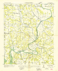
1936 Map of Union Hill
USGS Topo · Published 1936About this map
The agrarian landscape of the Alabama-Tennessee border comes into focus in this 1936 survey, just as the regional infrastructure began to shift under the Tennessee Valley Authority. Sugar Creek carves a central path through the terrain, flanked by a network of small family-centered settlements like Union Hill and Good Springs. The map documents a period of transition where traditional water-powered industry, such as Ridgeways Mill with its noted flume and the Mechanic Mill, existed alongside the newly rising waters of the Wheeler Reservoir.
Find a feature on this map
50 named features on this map. Tap any name to fly to it.
Don’t see what you’re looking for? This feature index may not catch every label — zoom into the map to look around manually.
Map Details
Editions of this 1936 Union Hill Map
This is the sole edition of this map. No revisions or reprints were ever made.
Other maps of this area

1914 · Rogersville
USGS Topo · 1:48,000

1916 · Rogersville
USGS Topo · 1:62,500

1936 · Aspen Hill
USGS Topo · 1:24,000

1936 · Thorntontown
USGS Topo · 1:24,000

1936 · Lexington
USGS Topo · 1:24,000

1936 · Ripley
USGS Topo · 1:24,000

1936 · Appleton
USGS Topo · 1:24,000

1936 · Cairo
USGS Topo · 1:24,000

1936 · Bonnertown
USGS Topo · 1:24,000
1936 · Salem
USGS Topo · 1:24,000