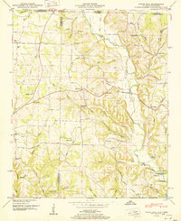
1951 Map of Union Hill
USGS Topo · Published 1951About this map
Lester and Union Hill sit near the Alabama-Tennessee border in this mid-century portrait of Limestone County's rural landscape. The area is defined by its deep drainages, notably Sugar Creek and the southern reach of the Elk River, which feeds into the Wheeler Reservoir reservation at the southeastern corner. This survey captures a community structured around its spiritual and educational centers, from the Hester Chapel and Beulah Ch to local schools like Rockaway Sch and Cairo Sch.
Find a feature on this map
69 named features on this map. Tap any name to fly to it.
Don’t see what you’re looking for? This feature index may not catch every label — zoom into the map to look around manually.
Map Details
Editions of this 1951 Union Hill Map
2 editions found
Other maps of this area

1914 · Rogersville
USGS Topo · 1:48,000

1916 · Rogersville
USGS Topo · 1:62,500

1936 · Union Hill
USGS Topo · 1:24,000

1936 · Aspen Hill
USGS Topo · 1:24,000

1936 · Thorntontown
USGS Topo · 1:24,000

1936 · Lexington
USGS Topo · 1:24,000

1936 · Ripley
USGS Topo · 1:24,000

1936 · Appleton
USGS Topo · 1:24,000

1936 · Cairo
USGS Topo · 1:24,000

1936 · Bonnertown
USGS Topo · 1:24,000