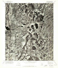
1971 Map of Union Hills
USGS Topo · Published 1972About this map
Adobe stands as a primary point of development within this 1971 orthophotomosaic, which reveals the transitioning landscape of northern Maricopa County. The imagery, captured by the Geological Survey, shows the desert floor beginning to transform with early residential street grids and industrial footprints carved into the arid terrain. The natural hydrology of the area is defined by the prominent paths of Skunk Creek in the west and Cave Creek toward the center, both cutting through the alluvial plains south of the rising Hills. This specific document captures a moment of suburban expansion just before the intensive growth that would later reshape this portion of the Phoenix metropolitan area, making it an essential reference for understanding the historical topography and land use patterns of the early 1970s.
Find a feature on this map
4 named features on this map. Tap any name to fly to it.
Don’t see what you’re looking for? This feature index may not catch every label — zoom into the map to look around manually.
Map Details
Editions of this 1971 Union Hills Map
This is the sole edition of this map. No revisions or reprints were ever made.
Other maps of this area

1904 · Camelback
USGS Topo · 1:62,500

1906 · Camelsback
USGS Topo · 1:62,500

1930 · Cave Creek
USGS Topo · 1:125,000

1939 · Cave Creek
USGS Topo · 1:125,000

1954 · Phoenix
USGS Topo · 1:250,000

1954 · Mesa
USGS Topo · 1:250,000

1957 · Mesa
USGS Topo · 1:250,000

1957 · Phoenix
USGS Topo · 1:250,000

1957 · Hedgpeth Hills
USGS Topo · 1:24,000

1957 · Glendale
USGS Topo · 1:24,000