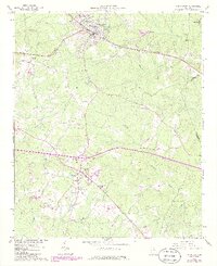
1965 Map of Union Point
USGS Topo · Published 1985About this map
Union Point serves as a significant rail hub in this mid-century survey, where the Seaboard line intersects the local landscape near Railroad Pond. The settlement pattern reflects the area's agricultural and industrial transition, with the community organized around the tracks and the nearby Wesleyan Campground. To the south, the village of Siloam is centered near Crumpton Lake, while the rural surroundings are dotted with family and church landmarks such as Darden-Thomas Cemetery and the Hubert English School.
Find a feature on this map
35 named features on this map. Tap any name to fly to it.
Don’t see what you’re looking for? This feature index may not catch every label — zoom into the map to look around manually.
Map Details
Editions of this 1965 Union Point Map
3 editions found
Other maps of this area

1906 · Crawfordville
USGS Topo · 1:125,000

1953 · Athens
USGS Topo · 1:250,000

1958 · Athens
USGS Topo · 1:250,000

1959 · Athens
USGS Topo · 1:250,000

1963 · Athens
USGS Topo · 1:250,000

1965 · Woodville
USGS Topo · 1:24,000

1965 · Union Point
USGS Topo · 1:24,000

1966 · Philomath
USGS Topo · 1:24,000

1966 · Crawfordville
USGS Topo · 1:24,000

1972 · Penfield
USGS Topo · 1:24,000