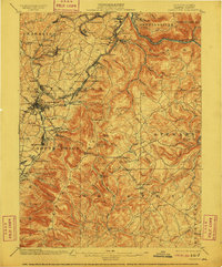
1900 Map of Uniontown
USGS Topo · Published 1910About this map
Fort Necessity and Braddocks Grave anchor this industrial and military landscape at the turn of the century, where the historic National Pike traverses the ridges of Fayette County. The map reveals an area defined by the intense carbon economy of the era, marked by numerous Coke Ovens and the sprawl of the H.C. Frick Coke Company operations. This industrial footprint is tied together by a complex web of rail, including the Baltimore and Ohio R.R. and the Pennsylvania R.R., which serve mining settlements like Monarch, Leisenring, and Dunbar. Away from the rail lines, the topography transitions into the steep hollows of the Laurel Highlands, featuring landmarks such as Dulany Cave and Washington Springs. The survey captures the transition from frontier history to the height of the coal and coke boom, providing clear locations for furnaces and forgotten station stops like Upper Middletown Station.
Find a feature on this map
112 named features on this map. Tap any name to fly to it.
Don’t see what you’re looking for? This feature index may not catch every label — zoom into the map to look around manually.
Map Details
Editions of this 1900 Uniontown Map
5 editions found
Other maps of this area

1900 · Accident
USGS Topo · 1:62,500

1900 · Uniontown
USGS Topo · 1:62,500

1900 · Masontown
USGS Topo · 1:62,500

1902 · Brownsville
USGS Topo · 1:62,500

1902 · Morgantown
USGS Topo · 1:62,500

1902 · Connellsville
USGS Topo · 1:62,500

1903 · Masontown
USGS Topo · 1:62,500

1904 · Bruceton
USGS Topo · 1:62,500

1906 · Brownsville
USGS Topo · 1:62,500

1922 · Confluence
USGS Topo · 1:62,500
Featured Places
- Uniontown, PA
- South Connellsville, PA
- Dunbar, PA
- Farmington, Wharton Township
- Chalkhill, Wharton Township