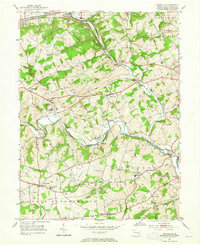
1953 Map of Unionville
USGS Topo · Published 1965About this map
The East Branch Brandywine Creek and West Branch Brandywine Creek converge south of Lenape, defining the rolling drainage of central Chester County during the early 1950s. The landscape is a patchwork of established agricultural townships like West Bradford and East Marlborough, interspersed with institutional landmarks such as the sprawling Embreeville State Hospital and the Philadelphia YMCA Camp. Small hamlets like Marshallton, Unionville, and Pocopson remain distinct rural centers connected by historic routes like Street Road.
Find a feature on this map
64 named features on this map. Tap any name to fly to it.
Don’t see what you’re looking for? This feature index may not catch every label — zoom into the map to look around manually.
Map Details
Editions of this 1953 Unionville Map
4 editions found
Other maps of this area

1901 · West Chester
USGS Topo · 1:62,500

1904 · West Chester
USGS Topo · 1:62,500

1904 · Coatesville
USGS Topo · 1:62,500

1905 · Honey Brook
USGS Topo · 1:62,500

1906 · Phoenixville
USGS Topo · 1:62,500

1906 · Coatesville
USGS Topo · 1:62,500

1907 · Honeybrook
USGS Topo · 1:62,500

1918 · Coatesville
USGS Topo · 1:62,500

1941 · Honeybrook
USGS Topo · 1:62,500

1943 · Coatesville
USGS Topo · 1:62,500
Featured Places
- West Goshen Township, PA
- Caln Township, PA
- Birmingham Township, PA
- Pocopson Township, PA
- Unionville, East Marlborough Township