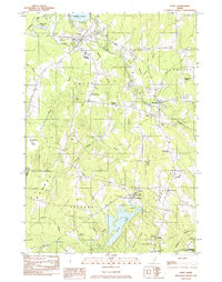
1982 Map of Unity
USGS Topo · Published 1983About this map
Unity Pond and the surrounding drainage of Twentyfive Mile Stream anchor this Waldo County landscape during the early 1980s. The town of Unity serves as a local hub, characterized by its eponymous Unity College and the specialized Unity Raceway to the west. The local economy and transport are defined by the Belfast and Moosehead Lake railroad, which tracks through the villages of Thorndike and Thorndike Center.
Find a feature on this map
54 named features on this map. Tap any name to fly to it.
Don’t see what you’re looking for? This feature index may not catch every label — zoom into the map to look around manually.
Map Details
Editions of this 1982 Unity Map
This is the sole edition of this map. No revisions or reprints were ever made.
Other maps of this area

1915 · Belfast
USGS Topo · 1:62,500

1916 · Liberty
USGS Topo · 1:62,500

1917 · Belfast
USGS Topo · 1:62,500

1926 · Burnham
USGS Topo · 1:62,500

1932 · Brooks
USGS Topo · 1:62,500

1941 · Belfast
USGS Topo · 1:62,500

1942 · Liberty
USGS Topo · 1:62,500

1948 · Bangor
USGS Topo · 1:250,000

1950 · Belfast
USGS Topo · 1:50,000

1950 · Liberty
USGS Topo · 1:50,000