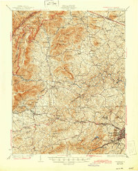
1931 Map of University
USGS Topo · Published 1944About this map
The University of Virginia anchors the southeastern corner of this landscape, marking the transition from the growing city of Charlottesville to the Blue Ridge mountains. The Chesapeake and Ohio railroad corridor serves as a primary artery through the Piedmont, connecting rural outposts like Ivy Depot and Crozet to the university center. To the west, the terrain rises sharply toward Shenandoah National Park, where the newly constructed Skyline Drive and the Appalachian Trail wind along the ridge. This era shows a densely populated rural landscape characterized by a high concentration of community institutions, including the Miller School, Farmington Country Club, and the Meriwether Lewis Sch. Numerous small settlements like Free Union and Nortonsville are linked by a network of drainage basins, most notably the Moormans River and Mechum River, which define the agricultural and social boundaries of Albemarle County.
Find a feature on this map
132 named features on this map. Tap any name to fly to it.
Don’t see what you’re looking for? This feature index may not catch every label — zoom into the map to look around manually.
Map Details
Editions of this 1931 University Map
2 editions found
Other maps of this area

1891 · Palmyra
USGS Topo · 1:125,000

1892 · Buckingham
USGS Topo · 1:125,000

1892 · Gordonsville
USGS Topo · 1:125,000

1892 · Harrisonburg
USGS Topo · 1:125,000

1895 · Palmyra
USGS Topo · 1:125,000

1897 · Palmyra
USGS Topo · 1:125,000

1929 · Covesville
USGS Topo · 1:62,500

1930 · Madison
USGS Topo · 1:48,000

1931 · University
USGS Topo · 1:62,500

1933 · Madison
USGS Topo · 1:62,500