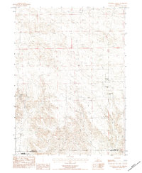
1983 Map of University Lake SE
USGS Topo · Published 1984About this map
Working ranches and open range dominate this Nebraska landscape along the border of Sioux and Scotts Bluff counties. The map details a high-plains environment where water and livestock management are central to the terrain, evidenced by several family-named operations including Prickett Ranch in the west and a cluster of properties belonging to the Applegate family, such as Applegate Ranch, E Applegate Ranch, and D Applegate Ranch. In the southwestern corner, the protected lands of the North Platte National Wildlife Refuge emerge, marking a transition toward the vital wetlands and habitats of the North Platte River system just beyond these borders.
Find a feature on this map
8 named features on this map. Tap any name to fly to it.
Don’t see what you’re looking for? This feature index may not catch every label — zoom into the map to look around manually.
Map Details
Editions of this 1983 University Lake SE Map
This is the sole edition of this map. No revisions or reprints were ever made.
Other maps of this area

1898 · Scotts Bluff
USGS Topo · 1:125,000

1898 · Camp Clarke
USGS Topo · 1:125,000

1899 · Whistle Creek
USGS Topo · 1:125,000

1951 · Kilpatrick Lake
USGS Topo · 1:62,500

1954 · Scottsbluff
USGS Topo · 1:250,000

1955 · Alliance
USGS Topo · 1:250,000

1957 · Alliance
USGS Topo · 1:250,000

1958 · Alliance
USGS Topo · 1:250,000

1958 · Scottsbluff
USGS Topo · 1:250,000

1963 · Scottsbluff North
USGS Topo · 1:24,000