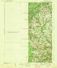
1938 Map of Upper Marlboro
USGS Topo · Published 1938About this map
Upper Marlboro serves as the focal point of this late 1930s landscape, illustrating the transition from rural agricultural land to early suburban development in Prince George's County. The infrastructure is defined by a mix of active and defunct transportation routes, most notably the Pennsylvania Railroad and its Popes Creek Branch, alongside the Chesapeake Beach Railway (Abandoned). This survey captures the region just before the post-war expansion of the Washington metropolitan area, showing scattered settlements such as Meadows, Forestville, and Seabrook amidst a dense network of drainage branches like Beaverdam Branch and Western Branch. Local social structures are clearly visible through the placement of rural institutions, including Holy Trinity Ch and the Collington Sch. The map provides a detailed view of several election districts, such as Queen Anne and Mellwood, preserving the administrative and community boundaries of a Maryland county seat at a pivotal moment in its growth.
Find a feature on this map
66 named features on this map. Tap any name to fly to it.
Don’t see what you’re looking for? This feature index may not catch every label — zoom into the map to look around manually.
Map Details
Editions of this 1938 Upper Marlboro Map
3 editions found
Other maps of this area

1890 · Mt. Vernon
USGS Topo · 1:125,000

1891 · Mt. Vernon
USGS Topo · 1:125,000

1892 · Laurel
USGS Topo · 1:62,500

1892 · Prince Frederick
USGS Topo · 1:62,500

1892 · Brandywine
USGS Topo · 1:62,500

1892 · Owensville
USGS Topo · 1:62,500

1893 · Frederick
USGS Topo · 1:125,000

1894 · Laurel
USGS Topo · 1:62,500

1894 · Frederick
USGS Topo · 1:125,000

1894 · Relay
USGS Topo · 1:62,500