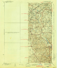
1938 Map of Upper Marlboro
USGS Topo · Published 1943About this map
Upper Marlboro serves as the focal point for this survey of Prince George’s County, Maryland, captured during a period of transition as the capital’s eastern suburbs began to expand. The landscape is defined by the winding course of the Western Branch and its tributaries, such as Collington Branch and Horsepen Branch, which shaped the early settlement patterns of the region. Local heritage is preserved in the numerous named church communities, including Holy Trinity Ch and St Barnabas Ch, alongside small rural schools like the Brown Sch. Transportation networks of the era are clearly delineated, from the legacy of the Pennsylvania railroad line and its connection at Croom Sta to the emerging arterial routes like the Defense Highway and Marlboro Pike, which would eventually facilitate the heavy growth of the mid-20th century.
Find a feature on this map
64 named features on this map. Tap any name to fly to it.
Don’t see what you’re looking for? This feature index may not catch every label — zoom into the map to look around manually.
Map Details
Editions of this 1938 Upper Marlboro Map
3 editions found
Other maps of this area

1890 · Mt. Vernon
USGS Topo · 1:125,000

1891 · Mt. Vernon
USGS Topo · 1:125,000

1892 · Laurel
USGS Topo · 1:62,500

1892 · Prince Frederick
USGS Topo · 1:62,500

1892 · Brandywine
USGS Topo · 1:62,500

1892 · Owensville
USGS Topo · 1:62,500

1893 · Frederick
USGS Topo · 1:125,000

1894 · Laurel
USGS Topo · 1:62,500

1894 · Frederick
USGS Topo · 1:125,000

1894 · Relay
USGS Topo · 1:62,500