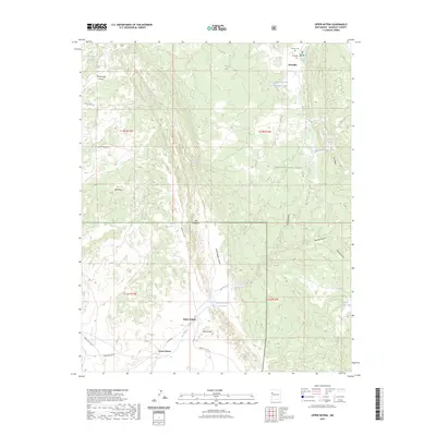
2023 Map of Upper Nutria
USGS Topo · Published 2023About this map
Upper Nutria and Lower Nutria anchor this portion of the Zuni Reservation, where the drainage of the Rio Nutria defines the local geography. The map illustrates a landscape of high mesas and deep draws, notably featuring the prominent ridge known as The Hogback and the steep slopes of Mexican Hill. To the north, the small community of McGaffey sits at the edge of the Cibola National Forest, providing a transition between the open arroyos and the wooded uplands of Oso Ridge. Water management is central to the area's layout, seen in the Nutria Diversion Reservoir and various tanks like Section Fourteen Tank. Local heritage is preserved at sites such as Torreon Cem and McGaffey Cem, while the network of tribal routes including Indian Svc Rte 31 and Nutria Rd connects the scattered settlements across this McKinley County terrain.
Find a feature on this map
48 named features on this map. Tap any name to fly to it.
Don’t see what you’re looking for? This feature index may not catch every label — zoom into the map to look around manually.
Map Details
Editions of this 2023 Upper Nutria Map
This is the sole edition of this map. No revisions or reprints were ever made.
Other maps of this area

1886 · Wingate
USGS Topo · 1:250,000

1892 · Wingate
USGS Topo · 1:250,000

1954 · Gallup
USGS Topo · 1:250,000

1958 · Gallup
USGS Topo · 1:250,000

1959 · Gallup
USGS Topo · 1:250,000

1962 · Gallup
USGS Topo · 1:250,000

1962 · Ciniza
USGS Topo · 1:24,000

1962 · Page
USGS Topo · 1:24,000
1963 · Ramah
USGS Topo · 1:24,000

1963 · Pinehaven
USGS Topo · 1:24,000