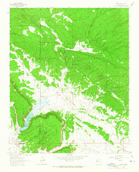
1963 Map of Ramah
USGS Topo · Published 1965About this map
Ramah serves as the central hub of this 1963 survey, situated south of the extensive Cibola National Forest. The landscape is defined by its agricultural and ranching heritage, featuring significant holdings like the Old Bond Ranch and Dent Ranch. For those tracing local genealogy, the map identifies the Mormon Colony Cem and the primary Ramah Cem, markers of the area's early settlement history. Water management is a critical element of this high-desert environment, anchored by the Ramah Reservoir and its Spillway, which controls the flow of Cebolla Creek. The surrounding terrain transitions into notable high points such as Wild Sheep Mesa and is carved by a network of drainage ways including Dan Valley, Harris Valley, and the dramatic The Falls. The boundary between McKinley and Valencia Counties cuts through the northern portion of the quadrangle, illustrating the political geography of the time.
Find a feature on this map
21 named features on this map. Tap any name to fly to it.
Don’t see what you’re looking for? This feature index may not catch every label — zoom into the map to look around manually.
Map Details
Editions of this 1963 Ramah Map
2 editions found
Other maps of this area

1886 · Wingate
USGS Topo · 1:250,000

1892 · Wingate
USGS Topo · 1:250,000

1954 · Gallup
USGS Topo · 1:250,000

1958 · Gallup
USGS Topo · 1:250,000

1959 · Gallup
USGS Topo · 1:250,000

1961 · Cottonwood Canyon
USGS Topo · 1:24,000

1962 · Gallup
USGS Topo · 1:250,000

1962 · Cottonwood Canyon
USGS Topo · 1:24,000

1962 · Page
USGS Topo · 1:24,000
1963 · Togeye Lake
USGS Topo · 1:24,000
Featured Places
- Eastern Navajo Agency, NM
- Ramah, Eastern Navajo Agency
- McKinley County, NM
- Cibola County, NM
- United States