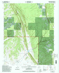
1995 Map of Upper Nutria
USGS Topo · Published 1998About this map
The Hogback dominates the central topography of this 1990s survey, a sharp geological divide that separates the high timber of the Cibola National Forest from the lower plateaus of the Zuni Indian Reservation. The mapping details a complex water management system essential to this arid landscape, centered around the Nutria Diversion Reservoir and the winding Rio Nutria. Small residential clusters at Upper Nutria and Lower Nutria are linked by the winding Nutria Road, while to the north, the community of McGaffey sits near the forest edge.
Find a feature on this map
28 named features on this map. Tap any name to fly to it.
Don’t see what you’re looking for? This feature index may not catch every label — zoom into the map to look around manually.
Map Details
Editions of this 1995 Upper Nutria Map
This is the sole edition of this map. No revisions or reprints were ever made.
Other maps of this area

1886 · Wingate
USGS Topo · 1:250,000

1892 · Wingate
USGS Topo · 1:250,000

1954 · Gallup
USGS Topo · 1:250,000

1958 · Gallup
USGS Topo · 1:250,000

1959 · Gallup
USGS Topo · 1:250,000

1962 · Gallup
USGS Topo · 1:250,000

1962 · Ciniza
USGS Topo · 1:24,000

1962 · Page
USGS Topo · 1:24,000
1963 · Ramah
USGS Topo · 1:24,000

1963 · Pinehaven
USGS Topo · 1:24,000