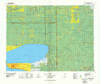
1977 Map of Upper Red Lake
USGS Topo · Published 1978About this map
Upper Red Lake dominates this northern Minnesota landscape, with the Red Lake Indian Reservation spanning its southern and western shores. The small community of Ponemah occupies the narrow point between the two massive basins, near the water passage known as the Narrows. This era shows a region defined by managed timberland and expansive wetlands, including the Pine Island State Forest and the Red Lake State Wildlife Management Area.
Find a feature on this map
28 named features on this map. Tap any name to fly to it.
Don’t see what you’re looking for? This feature index may not catch every label — zoom into the map to look around manually.
Map Details
Editions of this 1977 Upper Red Lake Map
This is the sole edition of this map. No revisions or reprints were ever made.
Other maps of this area

1918 · Winterroad
USGS Topo · 1:62,500

1918 · F
USGS Topo · 1:62,500

1918 · Zora
USGS Topo · 1:62,500

1919 · Peppermint Creek
USGS Topo · 1:62,500

1919 · Zora
USGS Topo · 1:62,500

1919 · G
USGS Topo · 1:62,500

1919 · Lundgren
USGS Topo · 1:62,500

1919 · Fox
USGS Topo · 1:62,500

1919 · Gemmell
USGS Topo · 1:62,500

1919 · Quiring
USGS Topo · 1:62,500