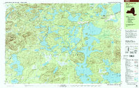
1999 Map of Upper Saranac Lake
USGS Topo · Published 2001About this map
Adirondack Park forms the sprawling backdrop for this 1999 survey, centered on the intricate waterways of Upper Saranac Lake. The landscape is a complex mosaic of glacial kettle ponds and interconnected lakes, where human presence is defined by recreation and conservation rather than heavy industry. At Saranac Inn, the built environment clusters around the water, while the nearby Adirondack Fish Hatchery highlights the region's managed wilderness character.
Find a feature on this map
107 named features on this map. Tap any name to fly to it.
Don’t see what you’re looking for? This feature index may not catch every label — zoom into the map to look around manually.
Map Details
Editions of this 1999 Upper Saranac Lake Map
This is the sole edition of this map. No revisions or reprints were ever made.
Other maps of this area

1902 · Saranac
USGS Topo · 1:62,500

1904 · Saranac
USGS Topo · 1:62,500

1904 · Santanoni
USGS Topo · 1:62,500

1904 · Long Lake
USGS Topo · 1:62,500

1905 · Saint Regis
USGS Topo · 1:62,500

1907 · Tupper Lake
USGS Topo · 1:62,500

1920 · Childwold
USGS Topo · 1:62,500

1921 · Childwold
USGS Topo · 1:48,000

1922 · Childwold
USGS Topo · 1:62,500

1948 · Ogdensburg
USGS Topo · 1:250,000