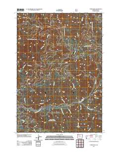
2011 Map of Upper Soda
USGS Topo · Published 2011About this map
Upper Soda serves as a focal point in this Linn County landscape, where the South Santiam River winds through a complex network of drainages. The area is defined by its significant vertical relief, marked by prominent landmarks such as Moose Mountain, Rooster Rock, and the strikingly named Bloody Point. To the north, Moose Lake sits near the headwaters of Moose Creek, while a web of forest access ways like Moose Mountain Rd and Soda Fork Rd provide the primary infrastructure for this timber-rich region. The drainage patterns of Little Boulder Creek, Stewart Creek, and Keith Creek illustrate the watershed's role in feeding the larger river system, reflecting the traditional land use and natural topography of the Oregon Cascades during the early 21st century.
Find a feature on this map
25 named features on this map. Tap any name to fly to it.
Don’t see what you’re looking for? This feature index may not catch every label — zoom into the map to look around manually.
Map Details
Editions of this 2011 Upper Soda Map
This is the sole edition of this map. No revisions or reprints were ever made.
Other maps of this area

1929 · Mill City
USGS Topo · 1:125,000

1934 · Mc Kenzie Bridge
USGS Topo · 1:96,000

1940 · Mc Kenzie Bridge
USGS Topo · 1:125,000

1953 · Salem
USGS Topo · 1:250,000

1954 · Salem
USGS Topo · 1:250,000

1955 · Cascadia
USGS Topo · 1:62,500

1955 · Echo Mountain
USGS Topo · 1:62,500

1956 · Quartzville
USGS Topo · 1:62,500

1956 · Detroit
USGS Topo · 1:62,500

1960 · Salem
USGS Topo · 1:250,000