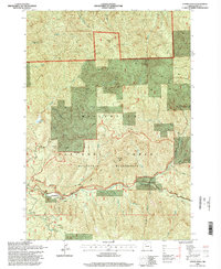
1994 Map of Upper Soda
USGS Topo · Published 1998About this map
Upper Soda and the winding course of the South Santiam River define this portion of the Cascade foothills in the mid-1990s. The map illustrates a landscape shaped by both recreation and historical transit, most notably the path of the Santiam Wagon Road which follows the river valley. This historic route is flanked by newer developments like the Long Bow Organizational Camp and the recreational access provided by the Menagerie Trail. Steep volcanic features such as Rooster Rock and Cougar Rock tower over the valley, while the presence of numerous quarries and gravel pits suggests the ongoing industrial use of the Willamette National Forest lands. The interior reaches of the Menagerie Wilderness are shown with their complex drainage systems, including Keith Creek and Trout Creek, where the terrain remains largely untouched by the road networks seen near Long Ranch.
Find a feature on this map
34 named features on this map. Tap any name to fly to it.
Don’t see what you’re looking for? This feature index may not catch every label — zoom into the map to look around manually.
Map Details
Editions of this 1994 Upper Soda Map
This is the sole edition of this map. No revisions or reprints were ever made.
Other maps of this area

1929 · Mill City
USGS Topo · 1:125,000

1934 · Mc Kenzie Bridge
USGS Topo · 1:96,000

1940 · Mc Kenzie Bridge
USGS Topo · 1:125,000

1953 · Salem
USGS Topo · 1:250,000

1954 · Salem
USGS Topo · 1:250,000

1955 · Cascadia
USGS Topo · 1:62,500

1955 · Echo Mountain
USGS Topo · 1:62,500

1956 · Quartzville
USGS Topo · 1:62,500

1956 · Detroit
USGS Topo · 1:62,500

1960 · Salem
USGS Topo · 1:250,000