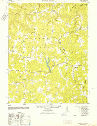
1952 Map of Upper Zion
USGS Topo · Published 1952About this map
The A P Hill Military Reservation dominates the landscape of Caroline and Essex counties, where the Army Map Service and USGS documented a network of rural settlements and specialized military infrastructure. The map reveals the early postwar configuration of the reservation, with numbered routes like Reservation Road 18 and Reservation Road 19 bisecting the terrain. Outside the military boundaries, traditional community life is anchored by family-named landmarks and rural congregations, including Enon Church, Ebenezer Baptist Church, and Salem Church. The placement of these institutions alongside local centers like Brandywine, Naulakla, and Upper Zion reflects a transition period where federal land acquisition for the reservation intersected with long-standing Virginia hamlets. Genealogists will find significant value in the documentation of scattered burial grounds such as Eagles Nest Cemetery and Rollins Cemetery, often located near crossroads like Hickory Fork and Liberty Fork.
Find a feature on this map
35 named features on this map. Tap any name to fly to it.
Don’t see what you’re looking for? This feature index may not catch every label — zoom into the map to look around manually.
Map Details
Editions of this 1952 Upper Zion Map
This is the sole edition of this map. No revisions or reprints were ever made.
Other maps of this area

1889 · Fredericksburg
USGS Topo · 1:125,000

1892 · Fredericksburg
USGS Topo · 1:125,000

1894 · Fredericksburg
USGS Topo · 1:125,000

1918 · Doswell
USGS Topo · 1:62,500

1918 · Aylett
USGS Topo · 1:62,500

1933 · Aylett
USGS Topo · 1:62,500

1942 · Bowling Green
USGS Topo · 1:31,680

1942 · Upper Zion
USGS Topo · 1:31,680

1942 · Occupacia
USGS Topo · 1:31,680

1942 · Rollins Fork
USGS Topo · 1:31,680