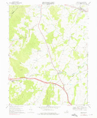
1970 Map of Upperville
USGS Topo · Published 1976About this map
Blue Ridge heights and the northern reaches of Fauquier County define this 1970 landscape, where the Appalachian Trail follows the ridge line above the valley. The area is characterized by scattered rural settlements and historic congregations, including Pleasant Vale Ch, Beulah Ch, and Emmanuel Ch. The Southern railway line serves as a central artery for the hamlets of Markham and Delaplane, connecting them to the larger agricultural region. Several prominent peaks such as Little Cobbler Mountain and Naked Mtn rise between the winding courses of Goose Creek and Crooked Run. This survey captures a moment in the early 1970s when small local landmarks like Harris Airfield and a lonely Quarry still punctuated the Piedmont terrain, while the county boundaries with Clarke and Loudon remain clearly demarcated along the high ridges and creek lines.
Find a feature on this map
31 named features on this map. Tap any name to fly to it.
Don’t see what you’re looking for? This feature index may not catch every label — zoom into the map to look around manually.
Map Details
Editions of this 1970 Upperville Map
Other maps of this area

1884 · Harpers Ferry
USGS Topo · 1:125,000

1891 · Harpers Ferry
USGS Topo · 1:125,000

1893 · Luray
USGS Topo · 1:125,000

1893 · Harpers Ferry
USGS Topo · 1:125,000

1894 · Warrenton
USGS Topo · 1:125,000

1894 · Winchester
USGS Topo · 1:125,000

1905 · Luray
USGS Topo · 1:125,000

1916 · Berryville
USGS Topo · 1:62,500

1938 · Winchester
USGS Topo · 1:48,000

1939 · Front Royal
USGS Topo · 1:48,000