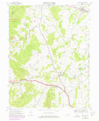
1970 Map of Upperville
USGS Topo · Published 1978About this map
Blue Ridge terrain defines this portion of Fauquier and Clarke Counties, where the Appalachian Trail follows the high ground overlooking the Piedmont. The landscape is characterized by prominent elevations such as Naked Mtn and Little Cobbler Mountain, with the valley floor below punctuated by small rural settlements and a series of historic houses of worship including Pleasant Vale Ch and Beulah Ch. The Southern railroad corridor and the winding course of Goose Creek serve as the primary east-west arteries through the gaps, connecting the crossroads of Markham and Delaplane. Land use in the late 20th century shows a mix of conservation and aviation, with the G Richardson Thompson State Wildlife Mgmt Area preserved on the ridge and small rural strips like Upperville Airport and Harris Airfield serving the local horse country near Upperville.
Find a feature on this map
33 named features on this map. Tap any name to fly to it.
Don’t see what you’re looking for? This feature index may not catch every label — zoom into the map to look around manually.
Map Details
Editions of this 1970 Upperville Map
Other maps of this area

1884 · Harpers Ferry
USGS Topo · 1:125,000

1891 · Harpers Ferry
USGS Topo · 1:125,000

1893 · Luray
USGS Topo · 1:125,000

1893 · Harpers Ferry
USGS Topo · 1:125,000

1894 · Warrenton
USGS Topo · 1:125,000

1894 · Winchester
USGS Topo · 1:125,000

1905 · Luray
USGS Topo · 1:125,000

1916 · Berryville
USGS Topo · 1:62,500

1938 · Winchester
USGS Topo · 1:48,000

1939 · Front Royal
USGS Topo · 1:48,000