
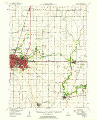
1957 Map of Urbana
USGS Topo · Published 1958About this map
The university hub of Urbana and neighboring Champaign anchor this late-1950s landscape, which exhibits a complex network of mid-century infrastructure and agricultural tradition. The urban core is flanked by the Urbana Country Club and landmarks like the Mt Hope Cem and the County Home, while the outskirts show the era's emerging roadside culture with a Drive-in Theater near Augerville. Beyond the city limits, the terrain transitions into a highly managed agricultural plain defined by the Saline Branch Drainage DITCH and the Upper Flatville Drainage DITCH, demonstrating the extensive drainage engineering required to farm the Illinois prairie.
Find a feature on this map
78 named features on this map. Tap any name to fly to it.
Don’t see what you’re looking for? This feature index may not catch every label — zoom into the map to look around manually.
Map Details
Editions of this 1957 Urbana Map
2 editions found
Other maps of this area

1906 · Urbana
USGS Topo · 1:62,500

1907 · Mahomet
USGS Topo · 1:62,500

1924 · Paxton
USGS Topo · 1:62,500

1927 · Paxton
USGS Topo · 1:62,500

1928 · Gibson City
USGS Topo · 1:62,500

1931 · Fithian
USGS Topo · 1:48,000

1936 · Potomac
USGS Topo · 1:62,500

1943 · Fithian
USGS Topo · 1:62,500

1949 · Paxton
USGS Topo · 1:62,500

1950 · Tuscola
USGS Topo · 1:62,500