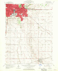
1957 Map of Urbana
USGS Topo · Published 1970About this map
Champaign and Urbana dominate the northern portion of this mid-century survey, revealing a landscape defined by rapid institutional and educational growth. The urban core of Cunningham TWP is densely packed with local landmarks, ranging from the University High Sch and Armory to the Burnham Hospital and Carle Hospital complexes. Significant land is dedicated to the dead and the living alike, with the large Mt Hope Cemetery bordering the developed areas.
Find a feature on this map
53 named features on this map. Tap any name to fly to it.
Don’t see what you’re looking for? This feature index may not catch every label — zoom into the map to look around manually.
Map Details
Editions of this 1957 Urbana Map
2 editions found
Other maps of this area

1906 · Urbana
USGS Topo · 1:62,500

1907 · Mahomet
USGS Topo · 1:62,500

1950 · Tuscola
USGS Topo · 1:62,500

1956 · Villa Grove
USGS Topo · 1:62,500

1957 · Urbana
USGS Topo · 1:62,500

1957 · Urbana
USGS Topo · 1:24,000

1957 · Rising
USGS Topo · 1:24,000

1957 · Mahomet
USGS Topo · 1:62,500

1957 · Bondville
USGS Topo · 1:24,000
1957 · Thomasboro
USGS Topo · 1:24,000