
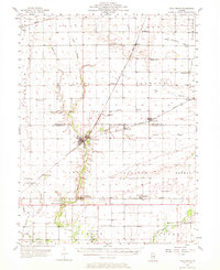
1956 Map of Villa Grove
USGS Topo · Published 1957About this map
Villa Grove and the surrounding agricultural townships of eastern Illinois are meticulously detailed in this mid-century survey. The landscape is defined by the rectilinear grid of section lines and the winding course of the Embarrass River, which passes near the recreational enclave of Patterson Springs and Spring Lake. Small farming settlements like Bongard, Murdock, and Longview serve as local hubs along the extensive rail networks of the Chicago and Eastern Illinois and the Baltimore and Ohio railroads.
Find a feature on this map
53 named features on this map. Tap any name to fly to it.
Don’t see what you’re looking for? This feature index may not catch every label — zoom into the map to look around manually.
Map Details
Editions of this 1956 Villa Grove Map
2 editions found
Other maps of this area

1906 · Urbana
USGS Topo · 1:62,500

1907 · Mahomet
USGS Topo · 1:62,500

1931 · Fithian
USGS Topo · 1:48,000

1935 · Arcola
USGS Topo · 1:48,000

1936 · Oakland
USGS Topo · 1:48,000

1940 · Arcola
USGS Topo · 1:62,500

1942 · Oakland
USGS Topo · 1:62,500

1943 · Fithian
USGS Topo · 1:62,500

1946 · Kansas
USGS Topo · 1:62,500

1949 · Kansas
USGS Topo · 1:62,500