
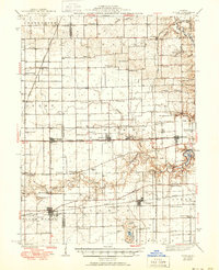
1943 Map of Fithian
USGS Topo · Published 1943About this map
The Salt Fork and Vermilion River carve through this section of East Central Illinois, defining a landscape shaped by both fertile agriculture and heavy transit infrastructure. This 1943 edition, based on earlier surveys by H.E. Simmons and others, documents the region's intense network of rural education and spiritual life, featuring dozens of localized institutions such as the Little Giant Sch, Black Sch, and Emberry Ch. The map captures the industrial character of the era, particularly through the intricate rail network including the Illinois Traction System and the Chicago and Eastern Illinois RR. These lines connected established towns like Fithian, Fairmount, and Oakwood to the surrounding coal and farm country. Researchers will note the concentration of named cemeteries like Stearns Cem and Bodkin Cem, which provide essential touchpoints for local family history and genealogy.
Find a feature on this map
85 named features on this map. Tap any name to fly to it.
Don’t see what you’re looking for? This feature index may not catch every label — zoom into the map to look around manually.
Map Details
Editions of this 1943 Fithian Map
2 editions found
Other maps of this area

1899 · Danville
USGS Topo · 1:62,500

1900 · Danville
USGS Topo · 1:62,500

1906 · Urbana
USGS Topo · 1:62,500

1924 · Paxton
USGS Topo · 1:62,500

1927 · Paxton
USGS Topo · 1:62,500

1931 · Fithian
USGS Topo · 1:48,000

1933 · Hoopeston
USGS Topo · 1:48,000

1936 · Potomac
USGS Topo · 1:62,500

1938 · Hoopeston
USGS Topo · 1:62,500

1947 · Ridge Farm
USGS Topo · 1:62,500