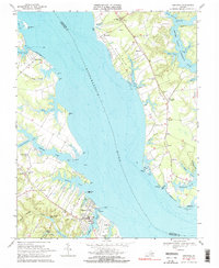
1968 Map of Urbanna
USGS Topo · Published 1971About this map
The Rappahannock River dominates this coastal landscape, separating Middlesex and Lancaster counties at a time when the water still dictated the pace of local commerce and travel. The town of Urbanna serves as a primary hub on the south shore, where the intricate finger-like inlets of Urbanna Creek and Robinson Creek provide deep natural harbors. Across the water, the rural character of the Northern Neck is evident in the cluster of small settlements like Mollusk, Ottoman, and Senora.
Find a feature on this map
75 named features on this map. Tap any name to fly to it.
Don’t see what you’re looking for? This feature index may not catch every label — zoom into the map to look around manually.
Map Details
Editions of this 1968 Urbanna Map
2 editions found
Other maps of this area

1916 · Kilmarnock
USGS Topo · 1:48,000

1917 · Heathsville
USGS Topo · 1:48,000

1917 · Urbanna
USGS Topo · 1:62,500

1917 · Morattico
USGS Topo · 1:62,500

1917 · Kilmarnock
USGS Topo · 1:62,500

1918 · Morattico
USGS Topo · 1:62,500

1926 · Morattico
USGS Topo · 1:62,500

1942 · Kilmarnock
USGS Topo · 1:62,500

1943 · Richmond
USGS Topo · 1:250,000

1944 · Morattico
USGS Topo · 1:31,680