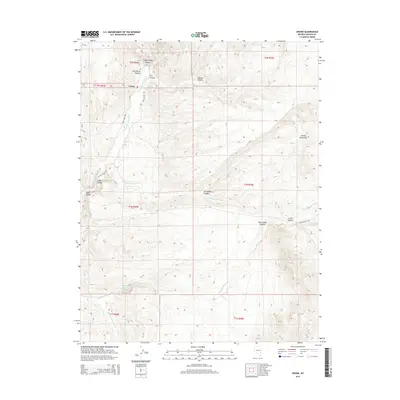
2014 Map of Ursine
USGS Topo · Published 2014About this map
Ursine serves as the central hub of this eastern Nevada landscape, where the confluence of the high desert and mountain canyons dictates the local geography. The settlement is positioned along the Meadow Valley Wash, a primary drainage system that shares the valley floor with the north-south Eagle Valley Rd. The terrain is defined by a series of dramatic incisions including Eagle Valley Canyon, Horsethief Canyon, and Serviceberry Canyon, which channel seasonal runoff toward the broader plains. Local water sources like Flatnose Ranch Spring suggest the historical importance of reliable water for ranching and homesteading in this arid environment. To the east, the elevation climbs significantly toward the Needle Mountains and Little Summit, reached by the winding path of Hackett Rd. The map illustrates a network of named washes, such as Immigration Wash and Flatnose Wash, which trace the historical movement of people and livestock through these high-altitude valleys.
Find a feature on this map
27 named features on this map. Tap any name to fly to it.
Don’t see what you’re looking for? This feature index may not catch every label — zoom into the map to look around manually.
Map Details
Editions of this 2014 Ursine Map
This is the sole edition of this map. No revisions or reprints were ever made.
Other maps of this area

1885 · Pioche
USGS Topo · 1:250,000

1886 · Pioche
USGS Topo · 1:250,000

1921 · NW 1/4 Panaca
USGS Topo · 1:48,000

1954 · Caliente
USGS Topo · 1:250,000

1956 · Lund
USGS Topo · 1:250,000

1959 · Caliente
USGS Topo · 1:250,000

1960 · Lund
USGS Topo · 1:250,000

1970 · Pierson Summit
USGS Topo · 1:24,000
1970 · Condor Canyon
USGS Topo · 1:24,000
1970 · Rose Valley
USGS Topo · 1:24,000