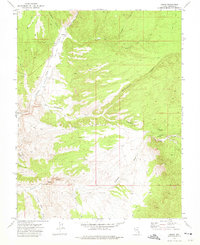
1972 Map of Ursine
USGS Topo · Published 1975About this map
Ursine serves as the primary settlement in this 1970s landscape, situated where the Eagle Valley Wash meets the expansive Meadow Valley. The town's local history is anchored by two cemeteries, labeled as Cems and Cem, reflecting its role as a persistent community in a region defined by high-desert drainage patterns. Further south, the Flatnose Ranch appears as a distinct agricultural outpost along the Flatnose Wash.
Find a feature on this map
26 named features on this map. Tap any name to fly to it.
Don’t see what you’re looking for? This feature index may not catch every label — zoom into the map to look around manually.
Map Details
Editions of this 1972 Ursine Map
This is the sole edition of this map. No revisions or reprints were ever made.
Other maps of this area

1885 · Pioche
USGS Topo · 1:250,000

1886 · Pioche
USGS Topo · 1:250,000

1921 · NW 1/4 Panaca
USGS Topo · 1:48,000

1954 · Caliente
USGS Topo · 1:250,000

1956 · Lund
USGS Topo · 1:250,000

1959 · Caliente
USGS Topo · 1:250,000

1960 · Lund
USGS Topo · 1:250,000

1970 · Pierson Summit
USGS Topo · 1:24,000
1970 · Condor Canyon
USGS Topo · 1:24,000
1970 · Rose Valley
USGS Topo · 1:24,000