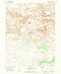
1964 Map of Uteland Butte
USGS Topo · Published 1966About this map
The Old Indian Treaty Boundary slices across this arid landscape in Uintah County, marking a significant historical line through the terrain. The topography is dominated by wide, flat terraces including Leland Bench and Eightmile Flat, which are broken by the prominent landmark of Uteland Butte. Modern resource extraction is evident in the mid-1960s with several Oil Wells scattered across the basin, often accessed by a network of Jeep Trails. To the south, the Green River winds past Wild Horse Bench, while the seasonal hydrology of the region is defined by the Pariette Draw and various washes that cut through the desert floor. This 1964 survey illustrates the intersection of mid-century industrial development and nineteenth-century territorial boundaries in a region defined by its extreme relief.
Find a feature on this map
16 named features on this map. Tap any name to fly to it.
Don’t see what you’re looking for? This feature index may not catch every label — zoom into the map to look around manually.
Map Details
Editions of this 1964 Uteland Butte Map
This is the sole edition of this map. No revisions or reprints were ever made.
Other maps of this area

1885 · East Tavaputs
USGS Topo · 1:250,000

1885 · Ashley
USGS Topo · 1:250,000

1917 · Vernal
USGS Topo · 1:125,000

1953 · Nutters Hole
USGS Topo · 1:62,500

1954 · Vernal
USGS Topo · 1:250,000

1956 · Grand Junction
USGS Topo · 1:250,000

1958 · Vernal
USGS Topo · 1:250,000

1959 · Grand Junction
USGS Topo · 1:250,000

1960 · Vernal
USGS Topo · 1:250,000

1960 · Grand Junction
USGS Topo · 1:250,000