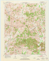
1953 Map of Utica
USGS Topo · Published 1973About this map
Utica and the surrounding agricultural lands are captured here during the early 1950s, a period when the local economy was defined by a mix of farming, small-scale oil extraction, and the established Louisville and Nashville railroad corridor. The landscape is characterized by a dense network of rural institutions, including Bethlehem Ch, Red Hill Ch, and New Bethel Ch, which serve as focal points for the scattered farmsteads. The presence of numerous Oil Wells across the northern and central sections highlights the mid-century energy production that dotted this part of Kentucky.
Find a feature on this map
33 named features on this map. Tap any name to fly to it.
Don’t see what you’re looking for? This feature index may not catch every label — zoom into the map to look around manually.
Map Details
Editions of this 1953 Utica Map
3 editions found
Other maps of this area

1906 · Sutherland
USGS Topo · 1:62,500

1907 · Whitesville
USGS Topo · 1:62,500

1909 · Whitesville
USGS Topo · 1:62,500

1909 · Hartford
USGS Topo · 1:62,500

1909 · Central City
USGS Topo · 1:62,500

1952 · Equality
USGS Topo · 1:24,000

1952 · Livermore
USGS Topo · 1:24,000

1953 · Philpot
USGS Topo · 1:24,000

1953 · Sutherland
USGS Topo · 1:24,000

1953 · Utica
USGS Topo · 1:24,000