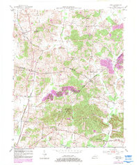
1953 Map of Utica
USGS Topo · Published 1983About this map
Agricultural lands and emerging oil fields define this Kentucky landscape along the borders of Daviess, McLean, and Ohio counties. The settlement of Utica serves as a local hub along the Seaboard railroad line, which cuts north-to-south through the terrain. The map reveals a deeply rooted community structure, marked by numerous rural sanctuaries including Bethlehem Ch, Greenbrier Ch, and Buck Creek Ch. Prominent physical landmarks such as Backbone Ridge and Barrett Hill rise above the drainage basins of Twomile Creek and the Rough R, which snakes along the southern boundary.
Find a feature on this map
35 named features on this map. Tap any name to fly to it.
Don’t see what you’re looking for? This feature index may not catch every label — zoom into the map to look around manually.
Map Details
Editions of this 1953 Utica Map
3 editions found
Other maps of this area

1906 · Sutherland
USGS Topo · 1:62,500

1907 · Whitesville
USGS Topo · 1:62,500

1909 · Whitesville
USGS Topo · 1:62,500

1909 · Hartford
USGS Topo · 1:62,500

1909 · Central City
USGS Topo · 1:62,500

1952 · Equality
USGS Topo · 1:24,000

1952 · Livermore
USGS Topo · 1:24,000

1953 · Philpot
USGS Topo · 1:24,000

1953 · Sutherland
USGS Topo · 1:24,000

1953 · Utica
USGS Topo · 1:24,000