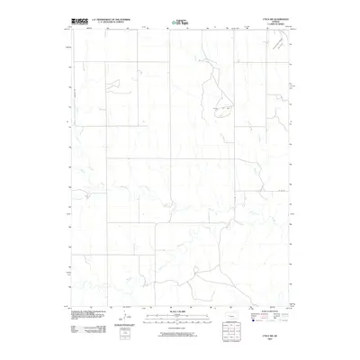
2009 Map of Utica SW
USGS Topo · Published 2009About this map
Walnut Creek and its numerous tributaries dominate this section of Ness County, Kansas, as they did during this 2009 survey. The drainage network is particularly complex here, where the North Fork Walnut Creek and Middle Fork Walnut Creek converge, joined by smaller flows such as Cottonwood Creek and Wild Horse Creek. This hydrological pattern defines the land use in the High Plains, where water availability has historically dictated the placement of homesteads and grazing lands.
Find a feature on this map
10 named features on this map. Tap any name to fly to it.
Don’t see what you’re looking for? This feature index may not catch every label — zoom into the map to look around manually.
Map Details
Editions of this 2009 Utica SW Map
This is the sole edition of this map. No revisions or reprints were ever made.
Other maps of this area

1955 · Scott City
USGS Topo · 1:250,000

1958 · Scott City
USGS Topo · 1:250,000

1965 · Beeler
USGS Topo · 1:24,000

1965 · Utica SW
USGS Topo · 1:24,000

1966 · Laird
USGS Topo · 1:24,000

1966 · Utica SE
USGS Topo · 1:24,000

1974 · Alamota
USGS Topo · 1:24,000

1974 · Pendennis
USGS Topo · 1:24,000

1974 · Shields SE
USGS Topo · 1:24,000
1981 · Arnold
USGS Topo · 1:24,000