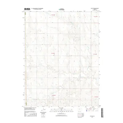
2015 Map of Utica SW
USGS Topo · Published 2015About this map
N Fork Walnut Cr and Middle Fork Walnut Cr carve their way through this section of the High Plains, illustrating the complex drainage patterns of Ness County and Lane County. This 2015 U.S. Geological Survey topographic map details the transition across the Lane County and Ness County line, where the landscape is defined by the repetitive grid of the Public Land Survey System. Local tributaries like Cold Springs Br, Wild Horse Cr, and Forrester Cr feed into the larger Walnut Creek system, creating a series of draws and ridges across the prairie. The map shows the established rural infrastructure, including Co RD 523 and various numbered section roads like 240 RD and 210 RD, which reflect the modern agricultural and transport layout of these Kansas plains.
Find a feature on this map
20 named features on this map. Tap any name to fly to it.
Don’t see what you’re looking for? This feature index may not catch every label — zoom into the map to look around manually.
Map Details
Editions of this 2015 Utica SW Map
This is the sole edition of this map. No revisions or reprints were ever made.
Other maps of this area

1955 · Scott City
USGS Topo · 1:250,000

1958 · Scott City
USGS Topo · 1:250,000

1965 · Beeler
USGS Topo · 1:24,000

1965 · Utica SW
USGS Topo · 1:24,000

1966 · Laird
USGS Topo · 1:24,000

1966 · Utica SE
USGS Topo · 1:24,000

1974 · Alamota
USGS Topo · 1:24,000

1974 · Pendennis
USGS Topo · 1:24,000

1974 · Shields SE
USGS Topo · 1:24,000
1981 · Arnold
USGS Topo · 1:24,000