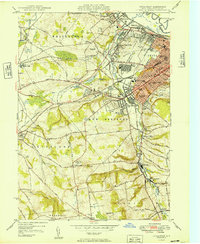
1949 Map of Utica West
USGS Topo · Published 1949About this map
The industrial corridor along Sauquoit Creek anchors this mid-century look at the western reaches of Utica and its neighboring mill towns. The landscape is defined by a dense network of transit and institution, where the New York Central Railroad and the historic Seneca Turnpike cut through the rolling terrain of Hart Hill and Burrstone Hill. Significant civic footprints are visible, including the sprawling Utica State Hospital and Mohawk College, alongside a concentration of religious and educational sites like the Lady of Lourdes Sch and Holy Trinity Ch.
Find a feature on this map
100 named features on this map. Tap any name to fly to it.
Don’t see what you’re looking for? This feature index may not catch every label — zoom into the map to look around manually.
Map Details
Editions of this 1949 Utica West Map
This is the sole edition of this map. No revisions or reprints were ever made.
Other maps of this area

1895 · Oriskany
USGS Topo · 1:62,500

1898 · Utica
USGS Topo · 1:62,500

1898 · Oriskany
USGS Topo · 1:62,500

1900 · Utica
USGS Topo · 1:62,500

1907 · Winfield
USGS Topo · 1:62,500

1907 · Sangerfield
USGS Topo · 1:62,500

1943 · Utica East
USGS Topo · 1:24,000

1943 · Cassville
USGS Topo · 1:24,000

1943 · Sangerfield
USGS Topo · 1:62,500
1943 · West Winfield
USGS Topo · 1:24,000