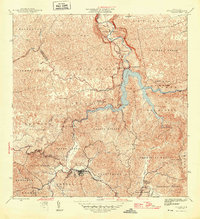
1946 Map of Utuado
USGS Topo · Published 1946About this map
Utuado serves as the central hub of this mid-century survey, situated at the confluence of several vital waterways including the Rio Vivi and the Rio Grande de Arecibo. The landscape is dominated by the sprawling Lago Dos Bocas, a reservoir created to support the Planta Hidroelectrica near the northern boundary with the Municipio de Arecibo. The map details a transition in the local economy and infrastructure, showing the relationship between early industrial efforts and established agricultural landmarks like Hacienda Carbonell. Rural life is anchored by local institutions such as the Iglesia San Pascual and the Escuela Segunda Unidad de Caonillas. The intricate topography of barrios like Salto Abajo and Caonillas Arriba reveals a complex network of mountain roads and ridges, including the prominent Cuchilla de Tetuan along the eastern edge.
Find a feature on this map
45 named features on this map. Tap any name to fly to it.
Don’t see what you’re looking for? This feature index may not catch every label — zoom into the map to look around manually.
Map Details
Editions of this 1946 Utuado Map
3 editions found
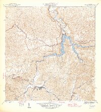
Other maps of this area

1938 · Camuy
USGS Topo · 1:20,000

1942 · Arecibo
USGS Topo · 1:30,000

1942 · Camuy
USGS Topo · 1:30,000

1942 · Barceloneta
USGS Topo · 1:30,000

1943 · Utuado NE
USGS Topo · 1:10,000

1946 · Barceloneta
USGS Topo · 1:30,000

1946 · Utuado
USGS Topo · 1:30,000

1946 · Bayaney
USGS Topo · 1:30,000

1946 · Jayuya
USGS Topo · 1:30,000

1946 · Monte Guilarte
USGS Topo · 1:30,000