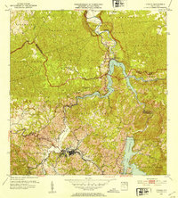
1952 Map of Utuado
USGS Topo · Published 1953About this map
Utuado serves as the central hub of this 1952 interior survey, where the Río Grande de Arecibo meets its tributaries amidst the steep topography of the Cordillera Central. The landscape is defined by the significant hydroelectric infrastructure of the mid-twentieth century, dominated by the reservoir of Lago Dos Bocas and the massive Lago Caonillas. The presence of the Central Planta Hidroeléctrica Caonillas indicates the industrial importance of water power in this era. Beyond the town center, smaller settlements like Las Palmas, Saltillo, and La Playa are connected by a network of winding roads and local watercourses like Río Limón and Río Guaónico. Rural life is visible through landmarks such as Iglesia San Pascual and the Hacienda Carbonell, illustrating the mix of religious community and agricultural history in the surrounding barrios.
Find a feature on this map
40 named features on this map. Tap any name to fly to it.
Don’t see what you’re looking for? This feature index may not catch every label — zoom into the map to look around manually.
Map Details
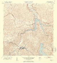
Editions of this 1952 Utuado Map
2 editions found
Other maps of this area

1938 · Camuy
USGS Topo · 1:20,000

1942 · Arecibo
USGS Topo · 1:30,000

1942 · Camuy
USGS Topo · 1:30,000

1942 · Barceloneta
USGS Topo · 1:30,000

1943 · Utuado NE
USGS Topo · 1:10,000

1946 · Barceloneta
USGS Topo · 1:30,000

1946 · Utuado
USGS Topo · 1:30,000

1946 · Bayaney
USGS Topo · 1:30,000

1946 · Jayuya
USGS Topo · 1:30,000

1946 · Monte Guilarte
USGS Topo · 1:30,000