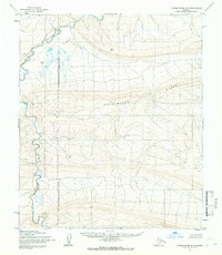
1955 Map of Utukok River A-5
USGS Topo · Published 1966About this map
Archimedes Ridge dominates the central topography of this Arctic landscape, where the Kokolik River winds through the western reaches. The map highlights a remote portion of the Naval Petroleum Reserve No 4 Boundary (Indefinite), reflecting mid-century strategic land management in the Far North. Small lakes such as David, Kelly, and Beno are scattered across the tundra, providing some of the few named landmarks in a region largely devoid of permanent settlements or infrastructure. Surveyed by the Army Map Service using aerial photography from the mid-1950s, the terrain is characterized by intricate contour intervals that reveal the complex drainage patterns and elevation changes across the North Slope before later modern developments reached this interior wilderness.
Find a feature on this map
7 named features on this map. Tap any name to fly to it.
Don’t see what you’re looking for? This feature index may not catch every label — zoom into the map to look around manually.
Map Details
Editions of this 1955 Utukok River A-5 Map
2 editions found
Other maps of this area

1951 · De Long Mountains
USGS Topo · 1:250,000

1951 · Utukok River
USGS Topo · 1:250,000

1951 · Point Lay
USGS Topo · 1:250,000

1951 · Misheguk Mountain
USGS Topo · 1:250,000

1955 · De Long Mountains
USGS Topo · 1:250,000

1955 · Point Lay
USGS Topo · 1:250,000
1955 · Utukok River A-5
USGS Topo · 1:63,360
1955 · Utukok River A-4
USGS Topo · 1:63,360

1955 · Point Lay B-1
USGS Topo · 1:63,360
1955 · Utukok River B-4
USGS Topo · 1:63,360