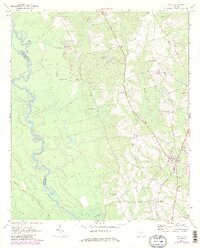
1970 Map of Uvalda
USGS Topo · Published 1986About this map
The Oconee River defines the western edge of this Montgomery County landscape, its meandering course creating a complex network of wetlands and oxbows, including the Dead River. Inland from the river, the land transitions into timbered tracts and agricultural fields centered around the town of Uvalda. This 1970s survey, updated with 1980s photorevisions, reveals a deeply rooted rural community evidenced by numerous family and community landmarks such as Old Salem Cem, McAllistor Cem, and St Johns Ch. The Central of Georgia railroad line serves as a primary transit corridor, passing through Uvalda and near Charlotteville in the southeast. Smaller water bodies like Rose Dew Lake and Milligan Creek drain the undulating terrain, while names like McAllistor suggest the historical legacy of local landholders.
Find a feature on this map
28 named features on this map. Tap any name to fly to it.
Don’t see what you’re looking for? This feature index may not catch every label — zoom into the map to look around manually.
Map Details
Editions of this 1970 Uvalda Map
3 editions found
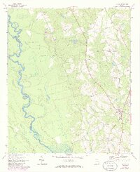
Other maps of this area

1953 · Waycross
USGS Topo · 1:250,000

1957 · Macon
USGS Topo · 1:250,000

1958 · Macon
USGS Topo · 1:250,000

1958 · Waycross
USGS Topo · 1:250,000

1964 · Macon
USGS Topo · 1:250,000

1970 · Glenwood
USGS Topo · 1:24,000

1970 · Alston
USGS Topo · 1:24,000

1970 · Mount Vernon
USGS Topo · 1:24,000

1970 · Vidalia
USGS Topo · 1:24,000

1970 · Uvalda
USGS Topo · 1:24,000