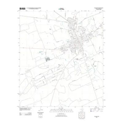
2013 Map of Uvalde
USGS Topo · Published 2013About this map
Fort Inge stands as a primary historical landmark on the eastern bank of the Leona River, marking a site of long-standing strategic importance south of the main settlement. The geography is defined by a network of drainage systems including Cooks Slough, Boon Slough, and Taylor Slough, which converge near Leona Springs. This water-rich landscape supports the Uvalde National Fish Hatchery, situated west of the river. The residential expansion is evident in the development of Uvalde Ests and the sprawling street grid that reaches toward Benson Airstrip. Local landmarks such as Inge Mtn and Rocky Hill provide topographic relief in an area otherwise characterized by the steady flow of the river and numerous named waterholes like Twomile Waterhole.
Find a feature on this map
128 named features on this map. Tap any name to fly to it.
Don’t see what you’re looking for? This feature index may not catch every label — zoom into the map to look around manually.
Map Details
Editions of this 2013 Uvalde Map
This is the sole edition of this map. No revisions or reprints were ever made.
Other maps of this area

1898 · Uvalde
USGS Topo · 1:125,000

1899 · Uvalde
USGS Topo · 1:125,000

1954 · San Antonio
USGS Topo · 1:250,000

1957 · San Antonio
USGS Topo · 1:250,000
1960 · Hacienda
USGS Topo · 1:24,000
1960 · Chalk Bluff
USGS Topo · 1:24,000

1960 · Pulliam Ranch
USGS Topo · 1:24,000
1960 · Sand Mountain
USGS Topo · 1:24,000
1971 · Sevenmile Hill
USGS Topo · 1:24,000
1971 · Garner Field
USGS Topo · 1:24,000