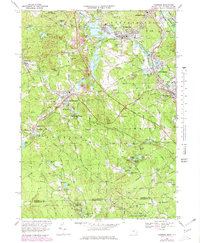
1969 Map of Uxbridge
USGS Topo · Published 1979About this map
The Mumford River carves through the industrial and residential heart of this Massachusetts-Rhode Island borderlands, anchoring a corridor of mill settlements like Whitinsville and Linwood. By the late 1960s, the landscape shows a dense network of institutional and community landmarks, from the St Camillus Hospital to the Northbridge High Sch. The town of Douglas and its neighbor East Douglas are central to the map, showing the growth of suburban neighborhoods alongside established local icons like the Douglas Center Sch and several prominent cemeteries including Evergreen Cem and St Denis Cem.
Find a feature on this map
133 named features on this map. Tap any name to fly to it.
Don’t see what you’re looking for? This feature index may not catch every label — zoom into the map to look around manually.
Map Details
Editions of this 1969 Uxbridge Map
4 editions found

Other maps of this area

1886 · Blackstone
USGS Topo · 1:62,500

1889 · Blackstone
USGS Topo · 1:62,500

1889 · Webster
USGS Topo · 1:62,500

1889 · Putnam
USGS Topo · 1:62,500

1889 · Burrillville
USGS Topo · 1:62,500

1892 · Webster
USGS Topo · 1:62,500

1893 · Putnam
USGS Topo · 1:62,500

1893 · Blackstone
USGS Topo · 1:62,500

1894 · Burrillville
USGS Topo · 1:62,500

1900 · Blackstone
USGS Topo · 1:62,500