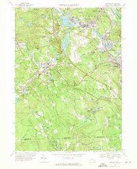
1969 Map of Uxbridge
USGS Topo · Published 1971About this map
Whitinsville and Uxbridge anchor this late-1960s landscape, where the Mumford River and Blackstone River historically powered the region's industrial growth. The map illustrates a complex water management system of reservoirs and ponds, such as Whitins Pond and Lackey Pond, which were vital to the local mills. Local transit and industry are clearly marked by the Penn Central rail line passing through East Douglas Station and Linwood.
Find a feature on this map
147 named features on this map. Tap any name to fly to it.
Don’t see what you’re looking for? This feature index may not catch every label — zoom into the map to look around manually.
Map Details
Editions of this 1969 Uxbridge Map
4 editions found
Other maps of this area

1886 · Blackstone
USGS Topo · 1:62,500

1889 · Blackstone
USGS Topo · 1:62,500

1889 · Webster
USGS Topo · 1:62,500

1889 · Putnam
USGS Topo · 1:62,500

1889 · Burrillville
USGS Topo · 1:62,500

1892 · Webster
USGS Topo · 1:62,500

1893 · Putnam
USGS Topo · 1:62,500

1893 · Blackstone
USGS Topo · 1:62,500

1894 · Burrillville
USGS Topo · 1:62,500

1900 · Blackstone
USGS Topo · 1:62,500