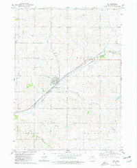
1980 Map of Vail
USGS Topo · Published 1981About this map
The East Boyer River valley forms the primary axis of this western Iowa landscape, where the town of Vail serves as the central hub. Tracing the river's path, the Chicago and North Western railroad cuts a straight line through the territory, highlighting the importance of rail transport for the agricultural townships of Milford, Westside, and Stockholm. The map reveals a rural landscape defined by a grid of farm roads and small creeks such as Rocky Run and Miller Creek.
Find a feature on this map
21 named features on this map. Tap any name to fly to it.
Don’t see what you’re looking for? This feature index may not catch every label — zoom into the map to look around manually.
Map Details
Editions of this 1980 Vail Map
This is the sole edition of this map. No revisions or reprints were ever made.
Other maps of this area

1954 · Omaha
USGS Topo · 1:250,000

1954 · Fort Dodge
USGS Topo · 1:250,000

1957 · Omaha
USGS Topo · 1:250,000

1957 · Fort Dodge
USGS Topo · 1:250,000

1958 · Omaha
USGS Topo · 1:250,000

1958 · Fort Dodge
USGS Topo · 1:250,000

1971 · Earling NE
USGS Topo · 1:24,000

1971 · Denison
USGS Topo · 1:24,000

1971 · Kiron
USGS Topo · 1:24,000

1978 · Manilla
USGS Topo · 1:24,000